Even though we’d visited the Rockies twice before we were still excited to return and hike some different trails. For our first few days we based ourselves in Canmore and did a few local hikes. The trails were within our beloved Kananaskis Country that I talked about in my previous post, but because they were close to the main highway from Calgary, they felt busy like the national parks.
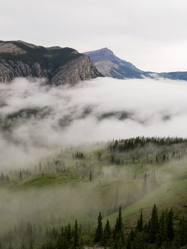
We’d spent two rainy days in a carpark and our first ‘good’ day was a double whammy of clouds – low lying fog and overcast above. But it wasn’t raining so we did a hike up to the summit of Mount Yamnuska. I was a bit grumpy, I don’t hike for exercise, I hike for the views and wildlife, so the idea of climbing a mountain in fog kind of irritated me. Craig did say that afterwards we could get a poutine (Canada’s legendary chips with cheese curds and gravy) which I’d been craving for a long while so that helped perk me up. The first section through a forest was strangely humid like a jungle and then we kept hearing sticks snapping. We paused to gauge the direction, figuring it was a bear, but it sounded like it was following us, so Craig let our a loud “hey bear” and then someone said “hello” and we cracked up laughing. It was an old guy running up the mountain and occasionally hitting his hiking poles together to warn bears.
After walking through the clouds we eventually climbed above them, and suddenly I wasn’t so grumpy. I love hiking above clouds, watching the scenes change within seconds as they drift, grow and fade around us. As we got even higher we got our first view of the peak as it rose out of the clouds and the sun gently hit the rocky wall.


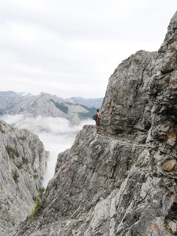
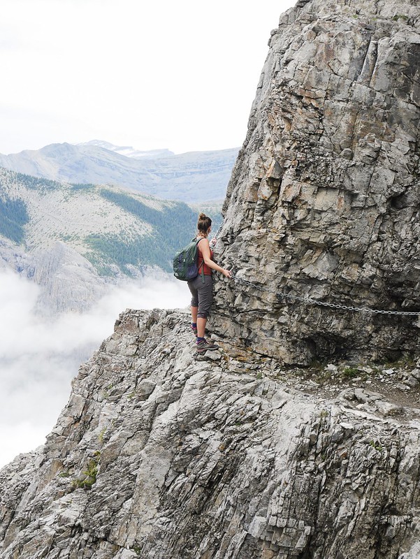
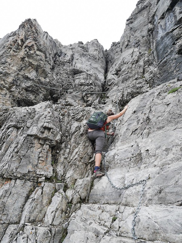
Soon after we reached a rocky mass of the mountain where we went through a chasm and a little detour led us to an almighty view. We were standing on the edge of a cliff where it dropped right down into the blanket of clouds. Certainly not a nice view for those who suffer from vertigo. The next challenge was a section where we had to shuffle along a cliff-edge where we had chains to hold onto. I was worried that we’d find this bit too scary but it was absolutely fine. The drop down wasn’t as severe as we’d expected so it’s a bit more comforting knowing that if we fell we’d probably just have broken bones. But the first chain happened to be very loose so as I pulled on it I went too far back for my liking. I was weary of the others but it was fine in the end and just involved putting my feet in the safest locations along the narrow ledge.


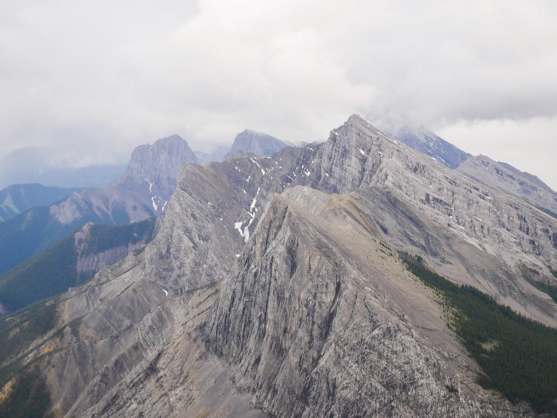
The rest was pretty simple up to the summit where we got a view of the pointy mountains and steep cliffs. We watched as the clouds drifted into the side of a mountain, almost swirling around like waves. The hike is well known for marking the start of the Rockies, as it offers a view of the mountains to the west and the flat prairies to the east, but due to the cloud we didn’t see too much of the surroundings. The route down was a speedy one, it was a loop trail and it’s highly encouraged to go anti-clockwise as the route we were taking down involved ‘scoria skiing’. It was a steep slope of shingle rock that sinks under each step, it would be a nightmare to walk up but a hell of a fun way to get down as we ran with our momentum, letting our feet slide a few feet down before jabbing the next foot down. By the time we reached the bottom the cloud had all burnt off and it was scorching in the sun. In one way it was a shame to not see the surroundings in clear weather but on the other hand the cloud made for a pretty unique experience, and I got my poutine as promised afterwards.


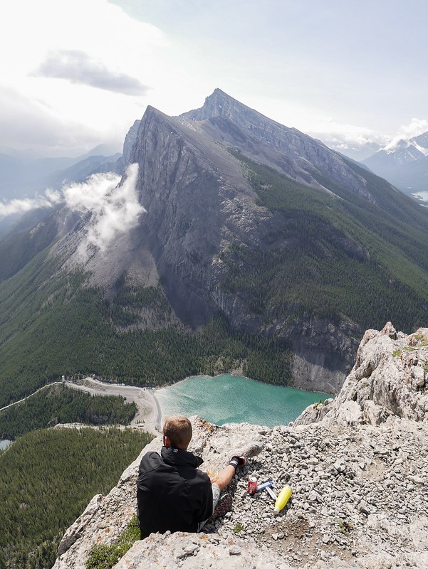
The following morning we opted for a hike up to the East End Of Rundle. It’s the most eastern peak of the Rundle mountain which has 8 summits along the mighty ridge line. The dirt road leading to the trailhead was in appalling condition and had us wiggling across the road trying to avoid the potholes. The hike was roughly 900m elevation gain in less than 3km, so quite a slog up but I seemed to have a spring in my step and we plowed up. On the way we had beautiful blue skies and a great view across the mountains and valley. Gradually a storm moved our way and after a scramble up to the summit we were rewarded with a 360° of cloud. It was windy as hell too so we didn’t spend long up there, just taking some snaps of us with a wildly flapping Canadian flag. We rushed back down the mountain and watched as the damn storm blew over and blue skies replaced it. We seem to have a habit of reaching summits in bad weather.
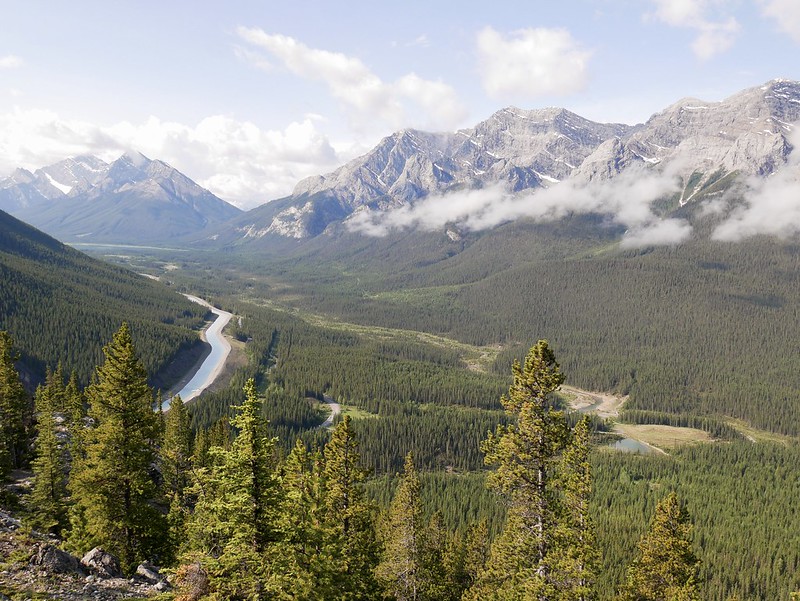


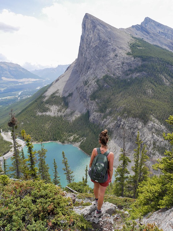
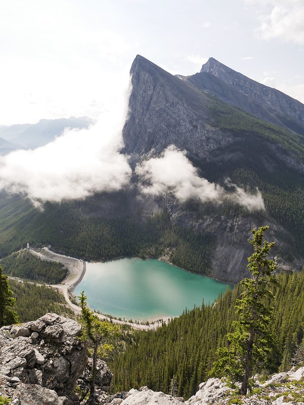
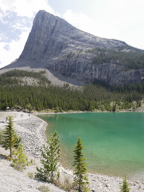
We stuck to the edge of the mountain on the way down to get some views of the valley below with the blue reservoir sitting beneath the mighty Ha Ling Peak. I don’t know if the views from the summit would be outstanding in good weather, but for us the best view was of Ha Ling and the majestic lake which only took half the amount of time to reach. We made it up and down in just 3.5hrs with a lunch break atop a rocky ledge.


We had just enough energy left to continue down to the popular Grassi Lakes. They were closed, along with many other hikes in k’country on our last visit in 2016 due to the abundance of berries attracting so many bears. It was a short, downhill path leading past rock climbers until we got a view down to the first of two crystal clear lakes. The best view is usually from above so we didn’t waste anymore energy and headed back to the van for a well needed cup of tea. Even better we finished the day with a paid shower at the Nordic Centre, it barely lasted long enough to get the soap off my body but it felt damn good to be clean(ish) after four days without a wash and then an intense rainbow appeared just before we went to bed.


amazing
colorful
adventure 🙂